The Migration of
Robert, Samuel & John McCorkle
from Virginia to Ohio, Kentucky & Missouri
(The inexorable pull of cheap land)
The will of Samuel McCorkle was dated
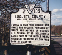
September 1, 1785 in Augusta County, Virginia. Samuel died near the end of 1788
as his will was probated on December 16 of that year. Samuel left his son
Sam Jr. about 80 acres “where he now lives”, so Sam Jr. was probably married at
this time. The balance of the “Plantation” was left to his wife Sarah with the
stipulation that this property would go to son John “at her decease”. Son
Robert received one shilling. Robert married Elizabeth Forrest on May 12, 1785
and John married Elizabeth’s sister Lydia on May 12, 1790. The Forrest’s were
from Orange County, North Carolina and, judging from Robert’s
Revolutionary War pension application, the couples probably met while Robert and
possibly John were in North Carolina on military duty. On September 17, 1793,
John and his wife Lydia sold their 256 acres to Jacob Swallow and on September
19, 1797, Samuel Jr. and wife Agnes sold their 80 acres to Michael Hite. Andrew,
another son of Samuel Sr., predeceased his father circa 1783. He left two sons,
William and Samuel.
The three McCorkles brothers did not
seem to make the journey from Augusta County, Virginia to Ohio and Kentucky at
the same time. Samuel, John and Robert were listed together for the last time on
the 1790 Augusta Tax List. In 1793 Samuel and John were listed. The last
Augusta County listing for Samuel was in 1795. On June 18, 1792, Robert was
taxed as shown on the Bath County List of James Vance. John joined Robert in
1794 and both were taxed in Bath through 1801. These dates dovetail with the
Augusta County dates very well. I have not seen the post-1801 Bath County lists.
Samuel McCorkle, one of the two sons of Andrew apparently accompanied John or
Robert to Bath County and was married there in 1798.
I have no proof, but I assume that the
Samuel and John McCorkle families traveled over the heavily used Great Wagon
Road to the Wilderness Trail and on to the Cumberland Trail. This route would
have taken them south through the Shenandoah Valley, through Lexington and
Abington, 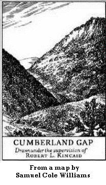 Virginia, through the Cumberland Gap to n
 ear
Boonesboro, Kentucky, where they would have followed the Green River west to
Greensburg. In March, 1802 William Barrett and wife sold Samuel McCoekle 200
acres in Green County, Kentucky for £85. On October 10, 1803, William Barret and
wife Dorothy sold John McCorkle 655 acres on Medow Creek in Green County for
$1627.50. In 1803, Samuel was taxed for 200 acres on Meadow Creek. Also listed
were two taxable males 16 to 21 years old. In 1805, Samuel listed two males over
21 and one male 16 to 21. In the same year, John was taxed on 650 acres on
Meadow Creek. In 1806, John, the son of Samuel was added to the lists and in
1807, Samuel III was taxed. On February 15, 1807, John bought another tract of
104 acres on Sinking Creek from Joseph Ray and on February 23 of that same year
he & Lydia sold their original 655 acres to Robert Mayes for $2000.
ear
Boonesboro, Kentucky, where they would have followed the Green River west to
Greensburg. In March, 1802 William Barrett and wife sold Samuel McCoekle 200
acres in Green County, Kentucky for £85. On October 10, 1803, William Barret and
wife Dorothy sold John McCorkle 655 acres on Medow Creek in Green County for
$1627.50. In 1803, Samuel was taxed for 200 acres on Meadow Creek. Also listed
were two taxable males 16 to 21 years old. In 1805, Samuel listed two males over
21 and one male 16 to 21. In the same year, John was taxed on 650 acres on
Meadow Creek. In 1806, John, the son of Samuel was added to the lists and in
1807, Samuel III was taxed. On February 15, 1807, John bought another tract of
104 acres on Sinking Creek from Joseph Ray and on February 23 of that same year
he & Lydia sold their original 655 acres to Robert Mayes for $2000.
There is a
McCorkle legend that John McCorkle, husband of Lydia, was
supposedly killed May 6, 1814 by renegades while on his way from Kentucky to
visit Robert in Ohio. This legend was apparently first published in a 1934
Huntington Advertiser newspaper article and then recopied and republished by
many, many others, including Louis McCorkle in his 1982 book From Viking
Glory. We have proven this legend to be completely untrue in every way.
To see the facts and complete story, click on the John McCorkle, the
Husband of Lydia Forrest was not Killed in 1814 link on the home page.
In any event, Lydia and her thirteen children soon moved to
Missouri where she is recorded as a taxpayer in Lincoln County in 1819. In 1812, the Missouri Territory was organized from the Louisiana
Purchase and was admitted to the Union as the 24th state on August 10, 1821.
Lydia’s son John stated in a letter (see below) to the Liberty (Missouri)
Tribune newspaper that the family moved to Missouri in 1816. A
biography of Lydia’s grandson, Nelson Monroe McCorkle, mentions that his
father, Alexander, moved to Cooper County, Missouri in 1818. In 1819, Lyd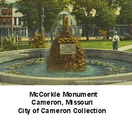 ia
was recorded as a taxpayer in Lincoln County, Missouri and between 1822 and
1824, Lydia and sons Robert, Samuel and John were taxed in Howard County,
Missouri. However, not all of Lydia’s family moved at the same time, since son
Archibald was taxed in Green County until 1823. On July 15, 1824, Archibald
patented 154 acres in Cooper County and on May 25, 1825, his brother Samuel patented 80 acres in Clay County. Samuel
went on to acquire over 1000 acres in Clinton and DeKalb Counties and, in 1854,
he founded the city of Cameron on the border of these two counties. Over the
next 30 years, the grandsons and great grandsons of Samuel and Sarah McCorkle of
Augusta County, Virginia recorded over thirty more patents in Clay, Buchanan,
DeKalb and Clinton counties. There was no 1830 census of Missouri, but in 1840
most of the family was recorded in Clay and Ray Counties, Missouri. Robert,
another child of John and Lydia McCorkle
left a will in 1867. However, not all of
the McCorkles settled in Missouri. In 1844, George Fristo McCorkle, the grandson
of John and Lydia, became the 1st McCorkle to reach the west coast when he and
his family made the journey to Oregon by wagon train. (See the George Fristo
McCorkle - Oregon Pioneer page)
ia
was recorded as a taxpayer in Lincoln County, Missouri and between 1822 and
1824, Lydia and sons Robert, Samuel and John were taxed in Howard County,
Missouri. However, not all of Lydia’s family moved at the same time, since son
Archibald was taxed in Green County until 1823. On July 15, 1824, Archibald
patented 154 acres in Cooper County and on May 25, 1825, his brother Samuel patented 80 acres in Clay County. Samuel
went on to acquire over 1000 acres in Clinton and DeKalb Counties and, in 1854,
he founded the city of Cameron on the border of these two counties. Over the
next 30 years, the grandsons and great grandsons of Samuel and Sarah McCorkle of
Augusta County, Virginia recorded over thirty more patents in Clay, Buchanan,
DeKalb and Clinton counties. There was no 1830 census of Missouri, but in 1840
most of the family was recorded in Clay and Ray Counties, Missouri. Robert,
another child of John and Lydia McCorkle
left a will in 1867. However, not all of
the McCorkles settled in Missouri. In 1844, George Fristo McCorkle, the grandson
of John and Lydia, became the 1st McCorkle to reach the west coast when he and
his family made the journey to Oregon by wagon train. (See the George Fristo
McCorkle - Oregon Pioneer page)
In 1870, the editor of the Clay County
Liberty Weekly Tribune requested that the long-time residents contribute short
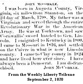 biographies
to the newspaper. A group of these biographies were published under the title of
“The Old Men of Clay County”. John McCorkle, one of the sons of John and Lydia
was over seventy two when his story was published on September 2, 1870. In the
aftermath of the Civil War, emotions were still very raw and many men that were
Confederate sympathizers or even suspected sympathizers had been denied the
right to vote. This article has been transcribed and reprinted in several books
on Clay County. The transcriber usually adds a parenthetical question mark
behind John’s mention of “Gen. Lincoln”. But old John knew his history well.
General Cornwallis was so embarrassed by his defeat at Yorktown that he sent
General O’Hara to present his sword to General George Washington. This breach of
protocol resulted in Washington appointing Major-General Benjamin Lincoln as his
substitute to accept the symbol of defeat. Washington's choice of General
Lincoln must have especially galling to Cornwallis since Lincoln had recently
been repatriated from British captivity in a prisoner exchange.
biographies
to the newspaper. A group of these biographies were published under the title of
“The Old Men of Clay County”. John McCorkle, one of the sons of John and Lydia
was over seventy two when his story was published on September 2, 1870. In the
aftermath of the Civil War, emotions were still very raw and many men that were
Confederate sympathizers or even suspected sympathizers had been denied the
right to vote. This article has been transcribed and reprinted in several books
on Clay County. The transcriber usually adds a parenthetical question mark
behind John’s mention of “Gen. Lincoln”. But old John knew his history well.
General Cornwallis was so embarrassed by his defeat at Yorktown that he sent
General O’Hara to present his sword to General George Washington. This breach of
protocol resulted in Washington appointing Major-General Benjamin Lincoln as his
substitute to accept the symbol of defeat. Washington's choice of General
Lincoln must have especially galling to Cornwallis since Lincoln had recently
been repatriated from British captivity in a prisoner exchange.
Another John McCorkle, this one the son of Samuel Jr., also moved to Missouri sometime after 1823 when he was last taxed in Green County. He probably traveled with the abovementioned Archibald. While in Green County, John was probably married three times: 1st to Anne Speer, 2nd to Patsy Redmond and lastly to Nancy Wright. On October 26, 1810, John witnessed a deed for property that his father-in-law, Samuel Spear purchased in Green County. He and his family are next found in the 1840 Clinton County, Missouri census, living near his 1st cousins, Samuel and James McCorkle.
On January 12, 1798, Samuel, the son of
Andrew McCorkle, married Elizabeth Hicklin in Bath County, Virginia. Samuel was
not taxed in Bath, but on April 16, 1799, he was
.gif) taxed
in Greenbrier County and on April 10, 1805 he purchased 260 acres on Muddy Creek
from John and Elizabeth Patterson for £170. He and Elizabeth sold this land to
John Conner on December 24, 1811, but Sam then acquired 30 acres on Mill Creek
from John Caraway on April 24, 1812. He supplemented his Mill Creek holdings in
August, 1812 with 105 acres purchased from James and Hannah Baker. Samuel
McCorkle was enumerated in the 1820 Greenbrier census with a wife, four boys and
two girls; however, he died prior to February 21, 1822, when Elizabeth was
bonded as administrator of his estate. At the beginning of the Civil War,
western Virginia seceded from the Confederacy and the state of West Virginia was
created. Greenbrier was among those counties that ended up in West Virginia.
Samuel’s son Sam Jr. and his descendants mainly stayed in western Virginia and
southern West Virginia, but the rest of his children (Jane, William, John,
Charles and Elizabeth) moved to Vermilion County, Illinois in the 1830s and
1840s. John seems to be the first to move to Vermilion as, on February 3, 1834,
he recorded a deed there for land he purchased from Morgan L. Payne on October
28, 1833. John also appears of the 1833 Vermilion County Property Tax List.
taxed
in Greenbrier County and on April 10, 1805 he purchased 260 acres on Muddy Creek
from John and Elizabeth Patterson for £170. He and Elizabeth sold this land to
John Conner on December 24, 1811, but Sam then acquired 30 acres on Mill Creek
from John Caraway on April 24, 1812. He supplemented his Mill Creek holdings in
August, 1812 with 105 acres purchased from James and Hannah Baker. Samuel
McCorkle was enumerated in the 1820 Greenbrier census with a wife, four boys and
two girls; however, he died prior to February 21, 1822, when Elizabeth was
bonded as administrator of his estate. At the beginning of the Civil War,
western Virginia seceded from the Confederacy and the state of West Virginia was
created. Greenbrier was among those counties that ended up in West Virginia.
Samuel’s son Sam Jr. and his descendants mainly stayed in western Virginia and
southern West Virginia, but the rest of his children (Jane, William, John,
Charles and Elizabeth) moved to Vermilion County, Illinois in the 1830s and
1840s. John seems to be the first to move to Vermilion as, on February 3, 1834,
he recorded a deed there for land he purchased from Morgan L. Payne on October
28, 1833. John also appears of the 1833 Vermilion County Property Tax List.
In the years 1809 through 1815, Robert
McCorkle was taxed in Kanawha County, Virginia. In 1810, Robert, Lydia, five
boys and three girls were enumerated in the Kanawha County census. There is no
way to tell exactly where in Kanawha the family lived, but the county had been
created in 1789 from Greenbrier and Montgomery Counties. Adjoining Kanawha to
the west was Cabell County which had been taken from Kanawha in 1809. Across the
Ohio River from Cabell was Gallia County, Ohio, the final destination of the
Robert McCorkle family. So, in the early 1800s, the McCorkles were fairly close
to their future home. However, finding the McCorkle family in this area was
something of a shock, because Kanawha was in the middle of some of the most
mountainous terrain in Virginia. I had assumed that their migration to Ohio
would have followed the Wilderness and Cumberland Trails into Kentucky and hence
to Ohio. However, my research into this puzzle uncovered the Kanawha Trace, an
Indian trail that is not nearly as well known as the aforementioned trails. The
Trace was a much shorter route to Ohio, basically following the New and Kanawha
River Valleys from southwestern Virginia to Point Pleasant on the Ohio River.
What is most interesting to me is that the Trace crossed the Wilderness Trail
very near Blacksburg, Virginia, a place that the McCorkles have left their mark.
Point Pleasant was also a location that the McCorkle's knew well as several of
the Augusta clan were part of the contingent of Virginia troops that battled a
force under the command of the
Shawnee chief Cornstalk there in 1774. In fact, General Andrew Lewis, the
leader of the Virginias, most likely led his men along the Kanawha Trace to
reach the spot that some historians consider the
first battle
of the American Revolution. However, for the McCorkle family that included
several young children, this route undoubtedly would have been a much more
arduous journey than the more southerly trail through the Cumberland Gap and
eastern Kentucky.
Robert McCorkle’s journey from Augusta
County to Ohio took about fifteen years. On February 19, 1807, Polly, the oldest
daughter was married to John Morrison in Greenbrier County, Virginia and on
January 2, 1811 Robert’s oldest son, James, was married in Montgomery County. So
the family lived in Bath, Greenbrier and possibly Montgomery Counties for
several years, but in 1810 another marriage took place when the Rev. John Lee
married Sarah, the McCorkles 2nd oldest daughter, to John Cantwell in
Kanawha County. A John Morison and family were recorded in the 1810 Kanawha
census just three listings away from the McCorkle family. Three census pages
away from the McCorkle's were John Cantrill and family. The Morrison and
Cantwell families continued on to Ohio with the McCorkle's.
Along with Illinois, Indiana, Michigan, Wisconsin and part of Minnesota, Ohio was part of the Northwest Territory which Congress established as public domain in 1787. The Northwest Territory was the first part of America where modern surveying techniques were extensively used. Lines of latitude and longitude were used instead of the older and very inaccurate system of metes and bounds. Metes and bounds used waterways, paths, roadways, trees and rocks to describe boundaries. This system was the cause of most of the lawsuits found in early American history. Kentucky, which was first a county of Virginia, then a state on June 1, 1792, was surveyed using metes and bounds.
Ohio Territory became the state of Ohio
March 1, 1803. Gallia was the southernmost county in Ohio until December
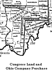 20,
1816, when Lawrence County was organized from the western section of Gallia and
parts of Jackson and Scioto counties. The area that the McCorkle's chose to
settle in was in the region called the Congress Lands, but very close to the
border with another section called the Ohio Company Purchase. Indeed, part of
the border between Gallia and Lawrence was formed by the original border between
the Congress Lands and the Ohio Company Purchase. Both of these extremely large
tracts were the result of the efforts of Congress to pay the debt that was a
result of the Revolutionary War. The Congress lands were administered by the U.
S. government and land was sold in several land offices in Ohio. Land
speculators formed the Ohio Company, then bought a huge tract from the
government and attempted to resell smaller plots. Much of this land was sold for
$1.00 to $2.00 per acre.
20,
1816, when Lawrence County was organized from the western section of Gallia and
parts of Jackson and Scioto counties. The area that the McCorkle's chose to
settle in was in the region called the Congress Lands, but very close to the
border with another section called the Ohio Company Purchase. Indeed, part of
the border between Gallia and Lawrence was formed by the original border between
the Congress Lands and the Ohio Company Purchase. Both of these extremely large
tracts were the result of the efforts of Congress to pay the debt that was a
result of the Revolutionary War. The Congress lands were administered by the U.
S. government and land was sold in several land offices in Ohio. Land
speculators formed the Ohio Company, then bought a huge tract from the
government and attempted to resell smaller plots. Much of this land was sold for
$1.00 to $2.00 per acre.
Why the McCorkles and their companions from Virginia chose the Lawrence County region to settle in is somewhat of a mystery to me. This region is quite hilly and mostly unsuitable for farming. The best farming lands are found along the Ohio River and the several larger streams that traverse the area. Most of these lands are subject to spring flooding which can be sometimes severe. In fact, the historical significance of Lawrence County is based on the vast iron deposits that were found there. Lawrence was part of the Hanging Rock Iron Region that flourished in the mid1800s. The Ohio historian, Henry Howe, states that Lawrence “was in 1825 almost an unknown wilderness, in 1845….it had 21 (iron) furnaces”. Mr. Howe spiced his county histories with stories about local inhabitants and his detailed account of a 1828 Lawrence County court action involving “Burning a Bewitched Horse” is interesting on several levels. Henry also relates that “when Lawrence was first organized, the commissioners neglected to lay a tax”. This policy made doing business with the county government difficult, but “eventually, the legislature passed laws compelling the commissions to lay a tax".
The first mention I have found of Robert McCorkle in Lawrence County records was June 7, 1817, when he was appointed as a tax lister (assessor). On October 16 of the same year, Robert was paid a $4.50 fee for Grand Jury service. Robert and Samuel McCorkle are listed on the 1818 Lawrence County Personal Property Tax Lists. In 1820, Robert and his family were enumerated in Union Township, Lawrence County, Ohio. By this time his son James and his family had rejoined the clan and sons Samuel and John had married were enumerated separately. Robert, Samuel and John were taxed for personal property in 1821. On 7 May 1821, John Morrison acquired a U.S. land patent at the Chillicothe, Ohio Land Office for 166 acres in Lawrence County, Ohio. On the patent document, John assigned the ownership to Robert McCorcle. John had previously married Robert's daughter Virginia Mary McCorkle in 1807 Greenbrier County, Virginia. At that time, the small surrounding community was called Russell’s Place; however, it latter became known as Getaway. The property location was Range 16, Township 1, Section 8, NW quarter. In 1822 Robert McCorcle was assessed $2.49 in property taxes on this land. On January 14, 1825, Robert deeded one acre of the farm to the Union Township School District No. 1 for $1.00 and, on April 12 of the same year, he received a license to operate a ferry across Symmes Creek “at his house and landing”. The 1825 prescribed rates were: man, 6 ¼ cents; man & horse, 12 ½ cents; wagon & horse, 15 cents. After Robert’s death in 1833, the remaining property was divided equally among his ten heirs; however, in 1835, this property was taxed in the name of Thomas Templeton, the husband of Elizabeth, another daughter of Robert McCorkle Sr.
On the right is a snippit from the northwest corner of a map of Union Township,
Lawrence County, Ohio. This map was published in 1887 in The Atlas of
Lawrence County, Ohio published by D. J. Lake & Co. On the west (left
side) of the map is the north to south flow ing
Indian Guyan Creek which entered the Ohio River some 4 miles to the south. At
the bottom center is the farm and home of F. McCorkle. This was Robert Forrest
McCorkle, the son of Samuel and Elizabeth Simmons McCorkle and the grandson of
Robert and Elizabeth Forrest McCorkle mentioned above. Robert married Athalia
Mount in 1863. Records show that Robert first purchased land at this location on
27 August 1852 from John Brammer.The paved road to north of the McCorkle
residence is now Highway 775 and a gravel road (now Private road 3153) led
to the McCorkle residence. Another branch of this unimproved road terminated
near Indian Guyan Creek at the adjacent farm of Henry C. McCorkle, the nephew of
Robert. On the west side of the McCorkle road at the junction junction of the
main road was/is McCormick Cemetery where Robert Forrest and Athalia Mount
McCorkle are buried along with many other local residents. Just north on the
main road was/is the Union Church where Robert and Athalia's daughter Effie
McCorkle and William Berton (Bert) McCaffrey were married. The exact name of the
church and associated cemetery seems to have changed several times. The
residence and country store of Bert's parents, William Sullivan and Jeanette
Smith McCaffrey is near the top center in the small unincorporated community of
Bartramville. The post office was in the McCaffrey store. Slightly south of the
McCaffrey store and across Five Mile Creek was the farm of Stephen P. Smith, the
brother of Jeanette Smith. Across the main road from the McCormick Cemetery was
the large farm of Isaiah Turley. His grandson, Edward Turley married Anna
McCorkle, another daughter of Robert and Athalia McCorkle. At the very top
center was the farm of C. (Clinton) and Mary Wakefield Forgey. Their son, Edgar
Forgey, married Louella McCaffrey, the daughter of William and Jeanette Smith
McCaffrey and the couple soon moved to Louisiana near New Orleans.
ing
Indian Guyan Creek which entered the Ohio River some 4 miles to the south. At
the bottom center is the farm and home of F. McCorkle. This was Robert Forrest
McCorkle, the son of Samuel and Elizabeth Simmons McCorkle and the grandson of
Robert and Elizabeth Forrest McCorkle mentioned above. Robert married Athalia
Mount in 1863. Records show that Robert first purchased land at this location on
27 August 1852 from John Brammer.The paved road to north of the McCorkle
residence is now Highway 775 and a gravel road (now Private road 3153) led
to the McCorkle residence. Another branch of this unimproved road terminated
near Indian Guyan Creek at the adjacent farm of Henry C. McCorkle, the nephew of
Robert. On the west side of the McCorkle road at the junction junction of the
main road was/is McCormick Cemetery where Robert Forrest and Athalia Mount
McCorkle are buried along with many other local residents. Just north on the
main road was/is the Union Church where Robert and Athalia's daughter Effie
McCorkle and William Berton (Bert) McCaffrey were married. The exact name of the
church and associated cemetery seems to have changed several times. The
residence and country store of Bert's parents, William Sullivan and Jeanette
Smith McCaffrey is near the top center in the small unincorporated community of
Bartramville. The post office was in the McCaffrey store. Slightly south of the
McCaffrey store and across Five Mile Creek was the farm of Stephen P. Smith, the
brother of Jeanette Smith. Across the main road from the McCormick Cemetery was
the large farm of Isaiah Turley. His grandson, Edward Turley married Anna
McCorkle, another daughter of Robert and Athalia McCorkle. At the very top
center was the farm of C. (Clinton) and Mary Wakefield Forgey. Their son, Edgar
Forgey, married Louella McCaffrey, the daughter of William and Jeanette Smith
McCaffrey and the couple soon moved to Louisiana near New Orleans.
Rev. Louis W. McCorkle relates that in 1810 Samuel McCorkle of Green Co., Kentucky “went with his brother Robert to Gallia Co., Ohio, where they bought 2100 acres on Bear Creek at 25 cents an acre in an area which became Lawrence Co., Ohio”. The Rev. McCorkle did no research whatsoever on this McCorkle line and he did not document the source of this information. I have never found any evidence at all to corroborate this story. Even in Texas, 2100 acres is a quite large amount of land, but there is no record of the McCorkle's patenting or otherwise purchasing this large amount of land, nor is there any record of them selling large parcels of property. Additionally, the figure of 25 cents an acre does not reflect the known land prices of the time. It seems that the details of this story are much more a legend than a fact.
Bibliography
Augusta County (Virginia) Clerk, Deed Books 1745-1866, Grantor Index L-R (LDS Film 30336)
Clark, Maria Taylor, Ohio Lands, Chillicothe Land Office, 1800 – 1829, Chillicothe, Ohio, June 1984
Creel, William L., The Creel-Crenshaw-Rigney-Stapp-Stewart- Suedekum Families
Howell, Henry, Historical Collections of Ohio; Containing a Collection of the Most Interesting Facts, Traditions, Biographical Sketches, Anecdotes, etc. Relating to its General and Local History with Descriptions of its Counties, Principal Towns and Villages, E. Morgan & Co., 1851
Howe, Henry, Historical Collections of Ohio, Vol. II - Lawrence, C. J. Krehbiel & Co., Cincinnati, Ohio, 1988
Jones, Dennis R., Bath County (Virginia) Personal Property Tax Lists 1791-1801, Bath County Historical Society
Knepper, Dr. George W., The Ohio Lands Book
Kounse, Martha J., McCorkle’s in the Lawrence County; Deed Book 1 & 2 Index 1818 - 1876
Lawrence County Auditor, Lawrence County, Ohio Tax Duplicates 1820-1827 (LDS Film 511785)
Historic Missouri Newspaper Project
McCorkle, Louis W., From Viking Glory: Notes on the McCorkle Family in Scotland & America, Herff Jones Co., Marceline, Missouri, 1982
Ohio, the Crossroad of Our Nation, Vol. 31, No. 1, The Ohio Genealogical Society, Mansfield, Ohio, Spring 1991
Shuck, Larry G., Greenbrier County (Virginia) Deed and Will Records, 1992
U. S. Department of Interior,
Bureau of Land Management, General Land Office Records
Shuck, Larry G., Greenbrier County (Virginia) Records,
Iberian Publishing Co., Athens, Georgia, 1989
Vermilion County Museum Historical Photos
Vermilion County (Illinois) Recorder, Deed Records 1832-1978, Grantee Index L-M (LDS Film 1316705)
Virginia Commissioner of Revenue (Kanawha County), Personal Property Tax Lists 1792-1850 (LDS Film 2024596)
Volkel, Charlotte A., et al., Tax and Land Records, Vermilion Co., State of Illinois, Illiana Genealogical Publishing Co., Danville, Illinois (LDS Film 0928107)
West
Virginia History Journal Vol. 56, "Manufactured
History: Re-Fighting the Battle of Point Pleasant",
West Virginia Archives and History,
1997
Wilderness Road Regional Museum
Wilson, Marcius, American
History: Comprising Historical Sketches of the Indian Tribes, Ivison &
Finney, Chicago, 1857
Wright, Barbara, Abstracts of Green County Kentucky Deed Books 3 & 4 1801 -
1806
Wright, Barbara, Abstracts of Green County
Kentucky Deed Books 5 & 6 1806 - 1814
To be continued
Click here to send me your comments, additions & corrections.
Revised 31 Mar 2021